MAJOR HIGHLIGHTS
Banff National Park was Canada’s first, North America’s second, and the world’s third national park. The Town of Banff and the Village of Lake Louise are the two main visitor service centres in the park. Described below are the park attractions outside of the Town of Banff and Lake Louise area.
| Established: | Size: | Number of visitors / year: |
| 1885 | 6,641 square km | about 4.7 million |
| 2,564 square mi |
1. Cascade Ponds
(5 km from Banff)
Picnic shelters and fire boxes, open meadows, clear shallow pools, and a small beach make this a favourite with locals and visitors alike.
2. Bankhead
(8 km from Banff)
A coal mine in a national park? It wouldn ’t be allowed today, but if you had been here 80 years ago you’d have seen a bustling, modern community (upper Bankhead) and a thriving industrial centre (lower Bankhead). Now you can discover what happened to this ghost town as you wander among the ruins, along the 1.1 km interpretive loop trail at lower Bankhead. Upper Bankhead is a peaceful spot for picnickers, and a trailhead for hikers.
3. Lake Minnewanka
(10 km from Banff)
It ’s Banff’s biggest lake, and a popular day use area with picnic shelters and a playground. During the summer there are commercial boat tours (403-762-3473) and guided fishing trips. Bighorn sheep are often seen here — please do not feed them.
4. Two Jack Lake
(12 km from Banff)
A pleasant spot for a picnic or a paddle.
5. Johnson Lake
(14 km from Banff)
There is an easy trail around this shallow lake, good wildlife-watching opportunities, picnic tables and a small beach
6. Sunshine Meadows
(15 km from Banff; 403-678-4099)
From the ski area parking lot you can walk or take the bus service up a steep 5 km road to the ski area (END JUN – END SEP). A selection of fine trails lead to stunning viewpoints, through vast alpine meadows full of wildflowers. Explore them yourself, or take a guided hike.
7. Johnston Canyon
(25 km from Banff)
A paved trail and exciting catwalks lead into this canyon and to two thundering waterfalls. It is 1.1 km to the Lower Falls (wheelchair accessible), and 2.7 km to the Upper Falls. For safety ’s sake, stay on the trail and away from the edge! Interpretive signs explain how and when the canyon was formed, and the unique habitat that has been created by the force of water on rock.
For the Columbia Icefield (130 km from LL), and points beyond, see Jasper National Park.
8. Crowfoot Glacier
(34 km from Lake Louise)
A beautiful pale-blue glacier visible from the highway, it was named a century ago when three toes of ice clung to the cliff. Today there are only two.
9. Bow Summit
and Peyto Lake
(40 km from Lake Louise)
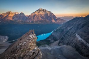
Bow Summit is the highest point on the parkway, at 2088 m above sea level. You are near treeline here, surrounded by alpine meadow. A short walk from the parking area leads to a viewpoint overlooking the blue-green Peyto Lake and, in July and August, an astonishing array of alpine flowers.
10. Mistaya Canyon
(72 km from Lake Louise)
Only ten minutes by trail from the road, the Mistaya River narrows into a twisting canyon. Look for rounded potholes and a natural arch on the canyon sides.
11. Saskatchewan River Crossing (77 km from Lake Louise)
Site of the old horse ford across the North Saskatchewan, the Crossing is close to the junction of three rivers. One of these, the Howse, was the route used in 1807 by fur trader and explorer David Thompson to cross the Great Divide. Today ’s David Thompson Highway (#11) leads east from the Crossing to Rocky Mountain House National Historic Site, where you can learn all about the days of the fur trade.
12. Parker Ridge
(120 km from Lake Louise)
Enjoy this ideal opportunity to experience the alpine zone. Sweeping mountain vistas, an outstanding view of the Saskatchewan Glacier, alpine flowers, and the chance to see ptarmigan and goats, are some of the attractions for those who take this steep (250 m elevation gain), but short (2.4 km round trip) hike. Please stay on the trail, and bring along warm clothing.
Be First to Comment